Bears Ears National Monument Top 5 Must See Sights


A few of our favorite places to visit in Bears Ears National Monument.
Overview
Travel back in time as you are met by the historical crossroads of Comb Ridge and the San Juan river. As the river is the only natural cut among the 900 foot high monocline cliff edges, its adjacent wash was forcefully the only manageable path for traveling within the 100 mile stretch of Comb ridge. Along this Ridge you may find remnants of ancient native dwellings, a portion of the Hole in the rock expedition route and the San Juan River itself.
The destination of River House ruin is a great example of the Ancestral puebloan dwellings that the area is commonly known for. This magnificent 14 room ruin is a delight to have the opportunity to see up close. Dating in the Pueblo III period between 950-1250 AD, its Sandstone walls and adobe mud exterior house two kivas, small remaining artifacts and vivid pictographs along the walls of the cliff dwelling. Around the left side of the main dwelling you may additionally find a grainery and petroglyphs about 100 meters down the path.
Directions
From Bluff head south on hwy 191- continuing straight on 163. As you approach the large cut in Comb Ridge, remember to look ahead immediately as you pass through to see the Bears Ears buttes sitting high on the horizon. As a friendly reminder, we ask that you refrain from stopping at the cut as it is a potential danger for falling rock. Continuing on, shortly after the cut you will turn left at the first road before the bridge. After passing a large cattle guard in the road, you will take a left and follow the winding roads along the wash heading East. At this point, the road continues toward the San Juan River and runs nearly parallel to Comb ridge-accessible only when the wash is dry by high clearance and 4WD vehicles. The road steeply climbs a short rocky section and continues on passed the sandy trail. Along the way you will partially follow the 1880’s trail of the Hole in the Rock Expedition. As the trail ascends San Juan Hill on the left, you will continue right to see to an open area of red rock ruts where the trail temporarily ends and you see the remnants of “Rincon” (Trading Post) to your right. Head past the Trading Post towards the remnants of the water wheel on your right and continue onto a narrow sandy road that will lead you another 3/4 mile to River house on your left.
Join us on a tour.
Overview
Butler Wash is the grand museum of archaeology in the Bears Ears National Monument. Hidden on the east side of Comb Ridge lie miles upon miles of side canyons full of rock art and cliff dwellings. Remember when visiting any of these places to visit with respect. One of the best sites to start with is the 1 mile round trip on a semi-paved trail to an overlook of one of the largest sites along Butler Wash. Enjoy a family friendly walk and learn about the desert flora as most of the plants along the trail are labeled.
Directions
From Bluff head north on 191 for 21 miles and turn left onto highway 95. Highway 95 is north gateway to Bears Ears, Cedar Mesa and beyond. Follow 95 for 10.1 miles and watch for the brown Butler Wash Ruins sign. There is a large parking area and pit toilets. A trail register and sign will lead you on a 1 mile round trip walk to an amazing site. Bring your binoculars and cameras. From the overlook there is a small hidden bridge about 200 yards to the north of the overlook along the rim. If you choose to hike to it watch your step, don’t fall off the cliff taking selfies and avoid the cryptobiotic soil. Cryptobiotic soil is very fragile and immensely important to the desert flora. Without this crust the soil would blow away! Stand and walk on the sandstone.
Overview
Make sure your camera is charged for this one. Once part of the Bears Ears National Monument, this little gem is hidden South of Bluff near Mexican hat. A 17-mile gravel road weaves through the towering formations of sculpted Cedar Mesa Sandstone dating back nearly 250 million years ago during the Permian period. Its monoliths, buttes and spires, though only a quarter of the size of the beloved Monument Valley offer awestruck views around every turn. A scenic and serene alternative to the vast crowds of visitors in Monument Valley. Keep your eyes peeled as the rock shape shifts around every corner. Admire the power of erosion in the stunning formation of the statues coming to life in the form of “Rooster Butte”, “Setting Hen”, “Seven Soldiers”, “Lady in a Tub” and so many more. Travel through in the evening to see the colors of the sun dance along the tower walls or stay the night as the skies open up to the billions of stars only visible in the absence of city lights.
Directions
From Bluff Head South on Hwy 191 and continue straight on 163 for another 17 miles then turn right onto Valley of the Gods road. A bumpy and often steep dirt trail, accessible by most vehicles including 2WD. At the end of the valley of gods road, the cross-street is 261 that then ascends the Moki Dugway of cedar Mesa to the right or will return back to 163 to the left.
Join us on a tour.
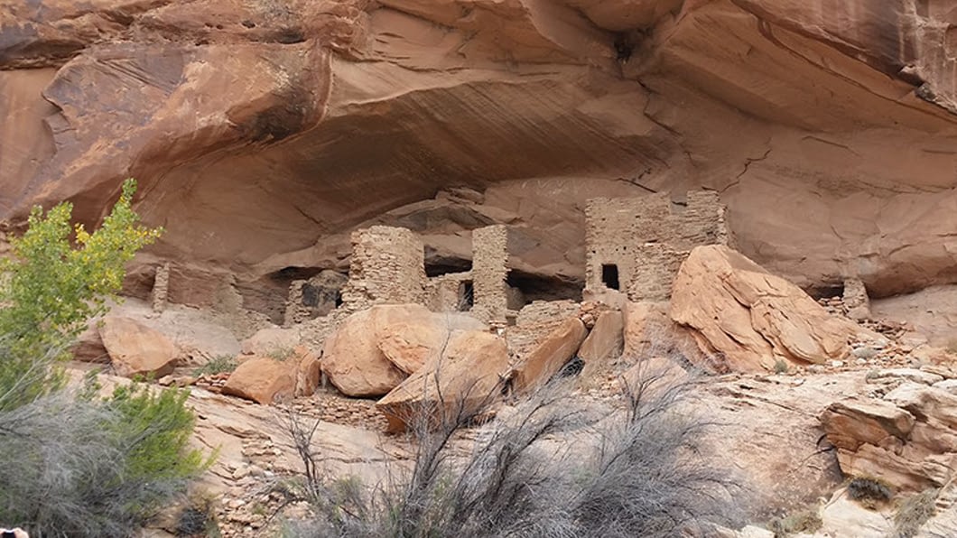
Overview
Located near the top of Mule Canyon Cedar Mesa at this site once stood 7 towers surrounding a beautiful spring that still flows today. Make sure you watch where you are walking so you don’t find yourself standing on a wall. Below the canyon rim is a village of cliff dwellings best viewed from the west rim of the canyon through binoculars. It is possible to hike down below the rim if your a mountain goat, but should only be done by hikers with good route finding skills and comfortable scrambling up and down steep slickrock slopes.
Directions
From Bluff head North on hwy 191 for 21 miles and turn left at Shirt Tail gas station for hwy 95. Head west for 19.4 miles passing through the cut in Comb Ridge. Continue on where you will see a sign for Texas flat road. Take a left onto a dirt road through an unmarked gate. Please close the gate behind you and it is a popular area for cattle. Follow the dirt road for a ¼ of a mile to a parking area with a sign and hike from here OR if you have a decent 4×4 you can continue down the road to another parking area about 1 mile further.
Join us on a tour.
Overview
A bucket-list overlook that offers a birds eye view of the winding Goosenecks of the lower San Juan River. On clear days you may look to the South to find the Pinnacles of Monument Valley. Stunning in any light, admire the maze of the river basin as the sandy red water winds through the mesa tops deep into the canyon.
Directions
From Bluff follow 191 south as it continues straight on to 163. Go several miles towards Mexican hat and make a right turn on to hwy 261 toward gooseneck state park. Continue straight on 261 towards Cedar Mesa and ascend the 1,200 foot “Moki Dugway”- an old mining road with tight but maintained switchbacks and paved turns. Once you reach the stop sign at the top of the dugway, take a slight left turn onto a dirt road and continue down until you reach a rocky pull off on the left.